Trails and area guide
Trail country, mapped from the front door
The City of Bella Vista counts 100 miles of trail inside its limits, and the lofts sit in the gap between its two big systems. Every distance on this page was measured from the building.
- Tunnel Vision · 0.3 mi
- Bike park · 0.5 mi
- Bentonville Square · about 15 min
The first mile
Out the door, onto dirt
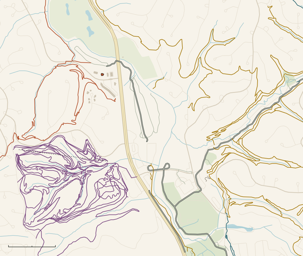
Two trail systems, a lift-served bike park and a paved greenway, all close enough that the car can stay parked.
-
Tunnel Vision and the Bluebird trailhead
0.3 mi · about 2 min by bike to the trail · 0.5 mi · about 8 min on foot to the trailhead
The way onto Little Sugar from this side of town. Bluebird Park has a short paved loop along the creek with trail art and benches, and the singletrack starts from its trailhead on Riordan Road.
-
OZ Trails Bike Park
0.5 mi · about 4 min by bike · about 15 min on foot
Lift-served downhill, beginner to expert, with a chairlift back to the top. A pass is required to ride; the restaurant and rooftop bar at the base are open to everyone. Lift days change with the season, so check the park’s site.
-
Razorback Greenway
Passes under US 71 just north of Riordan Road
The paved greenway now reaches the Bluebird trailhead. Local news reported the new link opening on October 20, 2026. From here it runs past Sugar Creek Center to Blowing Springs and south to Bentonville.
-
Sugar Creek Center
0.8 mi · about 7 min by bike · about 2 min by car
The nearest groceries and a few places to eat. Discover Bella Vista’s dining directory lists Allen’s Food (a grocery), Vagabond Coffee Bar, Las Fajitas and Top China here.
-
Blowing Springs trailhead
1.1 mi · about 8 min by bike
Green and blue loops along cliffs and springs, a campground, and the seasonal Gear Garden. OZ Trails describes Blowing Springs as a gateway into the Back 40.
- Little Sugar Lofts
- Bluebird trailhead
- OZ Trails Bike Park
- Razorback Greenway
- Sugar Creek Center
- Blowing Springs trailhead
The big picture
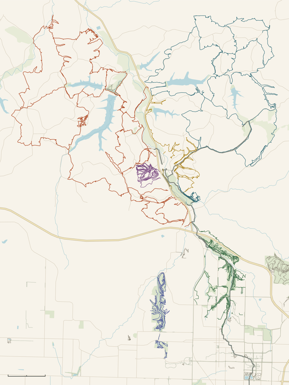
Six trail systems, one greenway
Little Sugar to the west, the Back 40 to the east, Bentonville to the south, and a paved path that ties them together.
- Little Sugar Lofts
- Kingsdale trailhead
- Blowing Springs trailhead
- Huntley Gravity Park
- Tanyard Creek
- Cooper Chapel
- Lake Ann trailhead
- Coler Mountain Bike Preserve
- Bentonville Square
- Crystal Bridges
- The Momentary
From the lofts
- Kingsdale trailhead1.2 mi · about 8 min by bike
- Blowing Springs trailhead1.1 mi · about 8 min by bike
- Huntley Gravity Park5.1 mi · about 10 min by car
- Tanyard Creek Nature Trail3.5 mi · about 7 min by car
- Mildred B. Cooper Memorial Chapel2.6 mi · about 4 min by car
- Lake Ann trailhead6.6 mi · about 15 min by car
- Coler Mountain Bike Preserve6.4 mi · about 15 min by car
- Bentonville Square6.3 mi · about 15 min by car
- Crystal Bridges7.4 mi · about 15 min by car
- The Momentary8.6 mi · about 15 min by car
- Little Sugar
- Back 40
- Blowing Springs
- OZ Trails Bike Park
- Slaughter Pen
- Coler
- Razorback Greenway and paved paths
Maps drawn for this site from OpenStreetMap data, © OpenStreetMap contributors, available under the Open Database License. Trail data as of November 9, 2026. Use an official trail map on the ground.
-
Bella Vista, west side
Little Sugar
Nearly 50 miles per City of Bella Vista
Built for mountain biking and open to people on foot. OZ Trails describes hollers and ravines, bluffs above Sugar Creek, a waterfall on Tanyard Creek, and road crossings carried through tunnels made of ten-foot pipe. It bills Little Sugar as the area’s all-weather system, with more climbing per mile than anywhere else in Northwest Arkansas.
- Tunnel Vision: 0.3 mi · about 2 min by bike
- Kingsdale trailhead: 1.2 mi · about 8 min by bike
-
Bella Vista, east side
The Back 40
Nearly 40 miles per City of Bella Vista
A 21.4-mile intermediate loop rings the network, with what OZ Trails calls grinding climbs and fast descents, and The Ledges for riders who want black diamonds. It opened in 2016.
- Blowing Springs trailhead: 1.1 mi · about 8 min by bike
- Lake Ann trailhead, the main access: 6.6 mi · about 15 min by car
-
Bella Vista, between the two
Blowing Springs
6.3 miles per Bella Vista POA
Natural-surface trail built for every level, along cliffs with caves and springs, including a cavern that breathes cool air. The kiosk map rates Low Rider and Rabbit Hole Loop Easy. The park has a campground, and the seasonal Gear Garden sits at the trailhead.
- Trailhead: 1.1 mi · about 8 min by bike
-
Bella Vista, at US 71 and Mercy Way
OZ Trails Bike Park
20+ miles, lift-served per OZ Trails Bike Park
More than 30 downhill-only trails from beginner to expert, with a chairlift. The base opened on June 12, 2026. A pass is required to ride.
- Base and chairlift: 0.5 mi · about 4 min by bike
-
Bentonville
Slaughter Pen
More than 30 miles per OZ Trails
Bentonville’s in-town network, in three phases running north from Compton Gardens toward Bella Vista, with the paved Razorback Greenway through all three. Cross-country loops, the downhill lines of the Castle hub, a skills park and a shaded beginner network.
- North end (Bark Park trailhead): 3.6 mi · about 25 min by bike
- Compton Gardens entrance: 6.1 mi · about 15 min by car
-
Bentonville, west of downtown
Coler Mountain Bike Preserve
More than 20 miles per Peel Compton Foundation
A free community preserve run by the Peel Compton Foundation: flow lines from a hilltop hub, easy loops, and a café reached only by trail. Open sunrise to 11 pm. Class 1 e-bikes are allowed.
- South Gateway: 6.4 mi · about 15 min by car
-
Fayetteville to Bella Vista
Razorback Greenway
About 40 miles, paved per Razorback Greenway
A paved shared-use trail joining seven communities. Since October 2026 it reaches the Bluebird trailhead beside the lofts, according to local news reports of the opening, which makes it the easy way to Blowing Springs, Slaughter Pen and downtown Bentonville.
- Bentonville Square by bike: 7 mi · about 45 min by bike
Rides by level
Pick a ride, not a fight
Ratings and mileage are the ones published by the City, the land owner or the trail’s own kiosk map. Where they disagree, we say whose number it is.
Beginner
Paved, green, or both. Good first rides, and good with kids.
-
Bluebird loop and the greenway
Paved · any distance
A short paved loop along the creek at Bluebird Park, then the Razorback Greenway for as far as you like, out and back. No singletrack skill needed.
Bluebird trailhead, 0.5 mi · about 8 min on foot
Source: Discover Bella Vista, NWA Trails & Bikeways (University of Arkansas CAST, NWARPC, Trailblazers), Razorback Greenway
-
Snowbird
About 1.5 miles · on the Back 40
A short Back 40 trail that the City’s trails FAQ names as one of the two most kid-friendly in town.
Snowbird parking, 4.2 mi · about 10 min by car
Source: City of Bella Vista, NWA Trails & Bikeways (University of Arkansas CAST, NWARPC, Trailblazers)
-
Low Rider and Rabbit Hole Loop
0.7 and 1 mile · Easy (kiosk map)
Short green laps at Blowing Springs, with the paved Blowing Springs Greenway alongside if anyone wants a break from dirt.
Blowing Springs trailhead, 1.1 mi · about 8 min by bike
-
In Bentonville: Esther’s Loop at Coler
4.5 miles · Easy, two-way (Peel Compton Foundation)
Rated Easy by the people who own the land, with a café in the middle of the preserve.
Coler, 6.4 mi · about 15 min by car
Source: Peel Compton Foundation
Intermediate
Where most of Bella Vista’s mileage is.
-
Tunnel Vision
28.8 miles (City) or a 25-mile loop (OZ Trails) · Intermediate
Rated Intermediate, but long, with about 1,500 feet of climbing for every 10 miles according to the trail group that oversaw the build. Most people ride a piece of it out and back from the trailhead next door, and save the full loop for a big day.
Nearest point, 0.3 mi · about 2 min by bike
Source: City of Bella Vista, OZ Trails
-
Down Under Loop
5 miles · Intermediate (City of Bella Vista)
A compact loop at the south end of Little Sugar; add Land Line for another 2.1 miles. The same hilltop reaches OZ 7 and OZ 8, two blue downhill-only trails that opened in 2026.
Source: City of Bella Vista, OZ Trails
-
The Back 40 Loop
21.4 miles · Intermediate (City of Bella Vista)
The east side’s signature loop. OZ Trails names Lake Ann trailhead as the main access. Bring water.
Lake Ann trailhead, 6.6 mi · about 15 min by car
Source: City of Bella Vista, OZ Trails
-
In Bentonville: Slaughter Pen’s cross-country core
About 3 miles to start
OZ Trails suggests Tristan’s, Red Barn and Ozone as a quick loop in the middle phase, with the flow hub nearby for more.
Source: OZ Trails
Advanced
Black diamonds, jump lines and a chairlift.
-
The Ledges, Summit School and Lookout
2.94, 0.5 and 0.35 miles · Expert/Advanced (City of Bella Vista)
The Back 40’s black diamonds. OZ Trails says The Ledges is named for the karst ledges it crosses.
Lake Ann trailhead, 6.6 mi · about 15 min by car
Source: City of Bella Vista, OZ Trails
-
Huntley Gravity Park
Invasion 0.29 mile · Very Difficult (kiosk map)
Purpose-built berms and jumps inside Little Sugar, with blues to warm up on and a climb trail back to the top. The downhill trails are for bikes only.
22 Huntley Ln, 5.1 mi · about 10 min by car
Source: OZ Trails
-
OZ Trails Bike Park
Lift-served · beginner to expert
Expert lines and a chairlift, close enough to ride to. A pass is required.
0.5 mi · about 4 min by bike
Source: OZ Trails Bike Park
-
The Staggerwing zone
Short gravity lines · up to Very Difficult
Steep descents at the north end of Little Sugar. Discover Bella Vista describes Staggerwing as a short, fast black-diamond gravity trail with a route back to the top; the regional trail database rates neighbouring Long Shadow Very Difficult.
Source: Discover Bella Vista, NWA Trails & Bikeways (University of Arkansas CAST, NWARPC, Trailblazers)
Eight lofts, eight trails
Find the trail on your door
Each loft is named for a trail on the Little Sugar system. Here is where each one runs, with the building marked for scale.
-
Loft 1
Tunnel Vision
About 25 miles · intermediate loop
Tunnel Vision is the outer loop of the Little Sugar trail system: about 25 miles of intermediate singletrack (the City of Bella Vista lists it at 28.8) that slips under roads through tunnels made of ten-foot pipe. Its nearest mapped point is a 0.3-mile pedal from the front door.
-
Loft 2
Long Shadow
About 0.3 mile · very difficult descent
Long Shadow is a short, steep, downhill-only line in the Staggerwing gravity zone at the north end of Little Sugar. The regional trail database rates it Very Difficult and maps it at about a third of a mile. The loft is considerably easier to get down.
-
Loft 3
Staggerwing
About 0.5 mile · gravity trail
Staggerwing is a short, fast gravity trail on Little Sugar built by Jagged Axe Trail Designs, with a route back to the top for repeat laps. No trail source says where the name comes from. One true thing: Bentonville-born pilot Louise Thaden won the 1936 Bendix Trophy flying a Beech Staggerwing.
-
Loft 4
Play Thru
About 0.8 mile · singletrack
Play Thru is about 0.8 mile of singletrack on the Little Sugar system, running along the Tanyard Creek side of town next to one of Bella Vista’s golf practice areas. The regional trail database rates it More Difficult.
-
Loft 5
Sugar Bridge
About 1.7 miles · singletrack
Sugar Bridge is about 1.7 miles of singletrack on the Little Sugar system, north of the lofts between the creek and the ridge. The regional trail database rates it More Difficult.
-
Loft 6
Down Under
5 miles · intermediate loop
Down Under is a five-mile intermediate loop at the south end of the Little Sugar system, built by Rock Solid Trail Contracting. The City of Bella Vista lists it as the Down Under Loop.
-
Loft 7
Rendezvous
0.5 mile · easy flow line
Rendezvous is the green line at Huntley Gravity Park, inside Little Sugar: a half-mile downhill flow trail rated Easy on the official map, and the one to start on before the blues and blacks.
-
Loft 8
Silent Hattie
About 0.2 mile · easy line
Silent Hattie is a short, easy line in the Staggerwing zone of Little Sugar, about a fifth of a mile on the regional trail map. No trail source explains the name. One true thing: "Silent Hattie" was the press nickname of Arkansas’s Hattie Caraway, the first woman elected to the U.S. Senate.
Before you roll
Conditions and manners
-
Open 5 a.m. to 10 p.m.
Bella Vista’s trails do not close for weather. The City asks riders to use judgment when it is wet or icy. (City of Bella Vista)
-
If you leave a print, it is too wet
That is the rule on OZ Trails’ kiosk maps for natural-surface trail. After rain, OZ Trails points riders to Little Sugar as the all-weather choice. (OZ Trails)
-
Bikes yield
Riders yield to everyone else, and downhill riders yield to uphill riders. Stay on the trail and pack out what you bring. (City of Bella Vista, Bella Vista Property Owners Association)
-
Class 1 e-bikes only
Pedal-assist (Class 1) e-bikes are the only motorized bikes allowed on Bella Vista’s trails. (City of Bella Vista)
-
Check conditions first
Friends of Arkansas Singletrack keeps a list of trail-condition groups for each system, and Visit Bentonville links to a live conditions feed. (Friends of Arkansas Singletrack (FAST), Visit Bentonville)
-
Tanyard Creek is for walking
The Tanyard Creek Nature Trail is the one trail in town not shared with bikes. (Discover Bella Vista)
Off the bike
Rest days and rain days
Bentonville’s museums are about 15 min down US 71. Opening days are the ones each place published when we checked; confirm before you go.
-
Crystal Bridges Museum of American Art
7.4 mi · about 15 min by car
American art, with trails through the grounds. General admission is free; some exhibitions are ticketed. Closed Tuesdays.
crystalbridges.org -
The Momentary
8.6 mi · about 15 min by car
Crystal Bridges’ space for contemporary art, music and food. General admission is free; some shows are ticketed. Closed Mondays.
themomentary.org -
Bentonville Square and the Walmart Museum
6.3 mi · about 15 min by car
The old town square, ringed by restaurants, shops and public art, plus the free Walmart Museum and its soda fountain.
downtownbentonville.org -
Scott Family Amazeum
7.4 mi · about 15 min by car
A hands-on museum for kids on Museum Way, the same road as Crystal Bridges. Ticketed. Closed Tuesdays.
amazeum.org -
Mildred B. Cooper Memorial Chapel
2.6 mi · about 4 min by car
A glass-and-steel chapel in the woods by architect E. Fay Jones, opened in 1988. Free to visit when no event is on.
cooperchapel.com -
Tanyard Creek Nature Trail
3.5 mi · about 7 min by car
About two miles on foot along Tanyard Creek, past a waterfall near the Lake Windsor dam. Walkers only.
Bella Vista POA trails -
Museum of Native American History
A free museum of Native American history in Bentonville. Closed Sundays and Mondays.
monah.org -
Lakes and golf
The POA says its golf courses are open to the public. Its lakes, pools and recreation centers need a guest pass, which we can request for you: ask at least five business days before you arrive, and expect the POA’s guest fee.
Bella Vista POA
On the calendar
Race weeks fill up first
Dates are the ones on each organizer’s site as of November 9, 2026. Check there before you book travel.
-
October 9–17, 2027
Life Time Big Sugar Classic
A week of racing based in Bentonville: Little Sugar MTB on October 10 (100K, 50K and 20K) and Big Sugar Gravel on October 16. In 2026 the mountain bike course started at OZ Trails Bike Park, down the road from the lofts.
bigsugarclassic.com -
September 22–26, 2027
Bentonville Bike Fest
Bentonville’s bike festival, created by pro rider Kenny Belaey. It was held in June in 2026 and moves to September for 2027.
bentonvillebikefest.com -
Memorial Day weekend in 2026
OZ Stage Race
Three days of mountain bike stage racing on OZ Trails in Bella Vista and Bentonville. Dates for 2027 had not been published when we checked.
Visit Bentonville -
December 5–6, 2026
Arkansas Downhill Series finale
The series ends its season at OZ Trails Bike Park.
arkansasenduroseries.com
Where this comes from
Trail facts come from the organizations that own, build or manage the trails, read on November 9, 2026. Distances and times were measured on November 9, 2026 from the building with open-source routing on OpenStreetMap data; bike times assume an easy pace and drive times are rounded up. If something here is out of date, tell us.
All 58 sources
- Discover Bella Vista: Bluebird
- City of Bella Vista: Mercy Way bridge news release (Bluebird Park and trailhead)
- NWA Trails & Bikeways (University of Arkansas CAST, NWARPC, Trailblazers): Regional trail database and map
- Little Sugar Lofts: Distances measured for this site from 10 Riordan Rd with OSRM routing on OpenStreetMap data (scripts/measure-distances.mjs)
- OZ Trails Bike Park: Home, hours and passes
- OZ Trails Bike Park: Trail map
- Arkansas Moves: Razorback Greenway Extension III groundbreaking (July 2026)
- Northwest Arkansas Democrat-Gazette: Greenway extension to the Bluebird trailhead opens (Nov. 1, 2026) (news report or third-party site)
- Razorback Greenway: About the greenway
- Discover Bella Vista: Dine
- Bella Vista Property Owners Association: Trails
- OZ Trails: Blowing Springs
- Bella Vista Property Owners Association: Restaurants (Gear Garden)
- City of Bella Vista: Little Sugar Trails
- OZ Trails: Little Sugar
- City of Bella Vista: The Back 40
- OZ Trails: Back 40
- OZ Trails: Little Sugar phase 2 now open (2020)
- OZ Trails: Blowing Springs kiosk map
- OZ Trails: Slaughter Pen
- OZ Trails: Slaughter Pen, phase by phase
- Peel Compton Foundation: Coler Mountain Bike Preserve: visit us
- Peel Compton Foundation: Coler Mountain Bike Preserve: mountain biking
- OZ Trails: Coler Mountain Bike Preserve
- City of Bella Vista: Trails FAQs
- OZ Trails: OZ 7 and OZ 8 sidecountry gravity trails (2026)
- OZ Trails: Huntley Gravity kiosk map
- OZ Trails: Huntley Gravity Zone
- Discover Bella Vista: The building of Little Sugar
- City of Bella Vista: Rules and trail etiquette
- Friends of Arkansas Singletrack (FAST): Trail conditions
- Visit Bentonville: Trail conditions
- Discover Bella Vista: Frequently asked questions
- Crystal Bridges Museum of American Art: Visit
- The Momentary: Home and hours
- Downtown Bentonville Inc.: The Bentonville Square
- Walmart: Walmart Museum: plan your visit
- Scott Family Amazeum: Visit
- Mildred B. Cooper Memorial Chapel: The chapel
- Museum of Native American History: Getting here
- Bella Vista Property Owners Association: Golf
- Bella Vista Property Owners Association: Frequently asked questions (guest passes)
- Bella Vista Property Owners Association: Guest pass request
- Life Time: Big Sugar Classic
- Life Time: Little Sugar MTB course
- Bentonville Bike Fest: Home
- Visit Bentonville: OZ Stage Race
- Discover Bella Vista: Events
- Arkansas Enduro Series: Schedule
- OpenStreetMap contributors: Map data (Open Database License)
- City of Bella Vista: Trails
- Arkansas Tourism: Bella Vista
- Phat Tire Bike Shop: Bella Vista shop
- Phat Tire Bike Shop: Bike rental, Bella Vista
- Phat Tire Bike Shop: Group rides
- Grindstone Coffee: Locations and hours
- Northwest Arkansas National Airport: Directions
- OZ Trails: Bella Vista